Wirral minor and field names
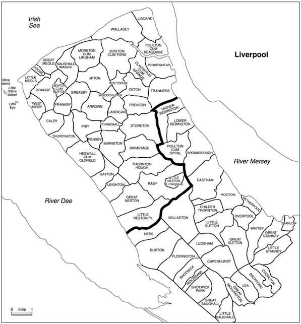
Wirral parish map (19th cent.). The bold line
demarks the approximate boundary of the 10th century Norse enclave,
based on baronial manor holdings and place names. Courtesy of Chester and
Cheshire Archives & Local Studies.
The Wirral
peninsula in north-west England was once home to a vibrant colony of
Scandinavian settlers, many of whom were Norsemen expelled from Ireland. The
arrival of one group was led by Ingimund in 902, but there were others,
including Danes. The intensity of the settlement is borne out by the
distribution of major or settlement names in Wirral, such as Arrowe, Caldy,
Claughton, Gayton, Larton, Lingham, Mollington Torold, Ness, Neston, Storeton,
Thingwall, Thurstaston, Tranmere, the -by names (Frankby, Greasby,
Helsby, Irby, Kirkby in Wallasey, Pensby, Raby, West Kirby, Whitby and the now
lost Haby, Hesby/Eskeby, Warmby, Kiln Walby, Stromby and Syllaby) and the
Norse-Irish Liscard and Noctorum. Some further settlement names, such as
Birkenhead, Heswall and Woodchurch, are of Anglian origin but were influenced
by the incoming Norsemen.
The
intensity of settlement can, however, perhaps best be gauged from the minor or
field names. Outstanding examples are brekka ‘slope, hillside’ (e.g. The
Breck, Flaybrick, Wimbricks and the Newton Breken), slakki ‘shallow
valley’ or ‘hollow’ (e.g. the Heswall Slack, the Bromborough Slack, Acre Slack
Wood and the West Kirby Slack, the many instances of ærgi ‘shieling, pastureland’ (e.g. Arrowe Park), þveit ‘clearing’ (e.g. the many thwaites in the Bidston area), klint ‘projecting
rock’ (e.g. the Clynsse stone (1642), now the Granny stone, at the
Wallasey Breck and the Clints at Brotherton Park, Bromborough), hestakeið ‘horse
race track’ (at Irby and Thornton Hough) and over 100 instances of the element rák ‘lane’.
The
Wirral carrs and holms
Of
particular interest are the 51 instances of kjarr (carr/ker) and
24 of holmr (e.g. Lingham) in north Wirral, names associated with marshy
land: kjarr is an Old Norse word meaning ‘brushwood; marsh; boggy land
overgrown with brushwood’ and holmr is Old Norse meaning ‘dry ground in a marsh;
island of useable land in a marshy area; a water meadow’. It is notable that
there are no instances in Wirral of the corresponding English names – elements such
as mersc ‘marsh’ and ēg ‘dry ground in a marsh’ – for the same features.
All names
were recorded in the 19th century tithe map apportionments or earlier.
Bidston: Bedestoncarre (1306; now
Bidston Moss), Wallacre, Oxholme, Olucar (1347), Holmegarth
Claughton: Near Holmes Wood, Further Holmes
Wood (1824)
Grange: Carr x2, Carr Farm, Carr Field
Great
Meols: Carr Side
Field, Carr Hall Farm, Carr Farm, Carr House, Carr Lane
Hoylake: Carr Lane
Landican: Carremedowe (1306) now Carr
Bridge Meadow, Carr Bridge Field, Near Carr Bridge Field
Leighton: Holme Hays
Little
Meols: Carr x2, Carr
Lane Field, Carr Field, Carr Side Hey, Carr Hey
Moreton
cum Lingham: Lingham,
Lingham Lane, Dangkers (now Danger) Lane, Bottom o’th’carrs, West Car, West
Carr Meadow, West Carr Hay, Holme Hay, Big Holme Hay, Little Holme Hay, Holme
Intake
Neston
(Great & Little):
Holme Heys
Newton
cum Larton: Newton
Car (1842), Sally Carr Lane (now footpath), Carr Lane, Carr, Carr Meadow,
Holmesides, Banakers
Overchurch
and Upton: Salacres#,
Salacre# Lane, Lanacre#, Hough Holmes, Le Kar (1294)
Oxton: Holm Lane, New Home (1831), Home
Field, Home Hey, Little Home, Carr Bridge Meadow, Carr Field Hey
Pensby: Carr House Croft
Prenton: Five Acre Holme, Bridge Holme, Top
Holme, Lower Holme, The Holme, Higher Holme
Saughall
Massie: Carr Farm,
Carr Houses, Carr Meadow, New Carr, Carr, Carr Hay, Old Carr Meadow, Old Carr
x2, Carr Lane
Wallasey: Wallacre Road/Waley-Carr, Routeholm
(1306)
Woodchurch: Lower Ackers#, Higher Ackers#
Great
Stanney: Holmlake
(1209)
Stanlow: Holmlache (1209)
# = last
element could be Old Norse kjarr or akr
Distribution map of field/track names in “carr” (filled circles) and “holm” (open circles)
Plotted on a map, they reveal an interesting trend and most congregate around the Rivers Birket and Fender. They suggest that much of north Wirral was of relatively low-quality farming land subject to flooding and tidal inundation, a feature that persisted through the centuries until the sea defences and embankments were constructed and completed in the late 19th/early 20th centuries.
Persistence
of a Scandinavian dialect
Studies by
scholars such as Kenneth Cameron (1997) have shown that the minor names in an
area tell us a great deal about the kind of vocabulary of the community. The
distribution of the carrs and holms taken alongside the
distribution of all minor names in Wirral with Scandinavian elements attest to
the persistence of dialect reflecting the intensity of the original settlement.
Distribution
map of field/track names containing Scandinavian elements. Square marks
Thingwall
Taken alone,
individual names describing a landscape feature are limited to the occurrence
of that feature – so that the distribution of carrs and holms shows
the concentration of boggy areas in Wirral as much as the Norse influence of
naming. The original Scandinavian words kjarr and holmr would
have been borrowed early into English as ker and holm, and the
evidence of the use of these elements in Wirral is all from after the Norman
Conquest, the earliest recorded examples being Holmlache (1209) in Stanlow
(perhaps the same place as Holmlake (1209) in Great Stanney, le Kar (1294)
in Overchurch and Routeholm (1306) in Wallasey, where holmr is
compounded with the Old Norse adjective rauðr ‘red’.
But perhaps the fact that the normal Old English words for these particular
topographical features are completely absent in these areas is of some
significance. The Norse-derived words had become the normal ones in Wirral when
the names were given.
Wirral was
not entirely boggy and uninviting. In Bidston, close to the Bedestoncarre and
Olucar, we have evidence of extensive clearing with large numbers of thwaite-names:
from the 19th century tithe apportionments (with earlier forms
recorded in 1644 or 1646) we find The Cornhill Thwaite, The Great Thwaite,
Marled Thwaite, Meadow Thwaite, Salt Thwaite, Spencer’s Thwaite, Tassey’s
Thwaite, Whinney’s Thwaite and the associated Thwaite Lane. Earlier we find Inderthwaite
and Utterthwaite (both 1522), the Thwaytes and Oldetwayt (both
1357). Around the centre of the Norse enclave, moreover, we still find, for
example, Youd’s and Bennet’s Arrowe, Brown’s Arrowe, Bithel’s Arrowe, Harrison’s
Arrowe, Widing’s Arrowe, Wharton’s Arrowe etc., as well as associated names
such as Arrowe Hill, Arrowe Bridge and Arrowe Brook, a tributary of the River
Birket. The persistence of this word of Celtic origin, adapted by Viking
settlers abroad is not only evidence of a continuing dialect but also of the
continuation of a type of farming used (and still used) by the Norwegians, i.e.
transhumance, whereby cattle and sheep are pastured away from the farmhouse
during summer months, saving the nearby pasture for winter fodder.
Conclusion
The
distribution of topographical minor names tells us as much about the
distribution of natural features as it does about the people who named them. In
the case of the Wirral carrs and holms, the high density in the
former Norse enclave tell us about the distribution of boggy ground before the
modern construction of the sea defences. It also reflects the persistence of
the Scandinavian dialect throughout the centuries, and the absence of the
corresponding English names for the same feature is testament to the dominance of
this dialect in the medieval period.
Acknowledgements
The help
and advice of Dr. Paul Cavill of the English Place Name Society is gratefully
appreciated, as is that of Howard Mortimer (Wirral Council), Peter France and
John Emmett (local archaeologists). The help and patience of Paul Newman, Derek
Joinson, Margaret Cole, Caroline Picco and John Hopkins of Chester and Cheshire
Archives & Local Studies is also very much appreciated.
This is
an abridged version of an article originally written by Steve Harding and
published in the Journal of the English Place-Name Society in 2007.
Harding, S.E. (2007). The Wirral Carrs and Holms. Journal of
the English Place-Name Society 39, 45–57.
https://www.nottingham.ac.uk/ncmh/documents/dna/JEPNS-Nov-Dec2007.pdf
More articles about Vikings can be read on Steve’s Wirral
and West Lancashire Viking page:
https://www.nottingham.ac.uk/ncmh/vikings/wirral-and-west-lancashire-viking-page.aspx
Further
details of Wirral place names (and more) can be found in Ingimund’s Saga –
Viking Wirral (Third Edition):
https://www.amazon.co.uk/Ingimunds-Saga-Viking-Stephen-Harding/dp/1908258306/ref=sr_1_1?crid=1VKVC9RN6DWAA&keywords=Ingimunds+Saga&qid=1645426500&sprefix=ingimunds+saga%2Caps%2C85&sr=8-1
Sue
Bishop and Steve Harding


Comments
Post a Comment