The Wirral carrs & holms, Meols & their relevance to the Battle of Brunanburh (taken from the Journal of the English Place Name Society, 2007)
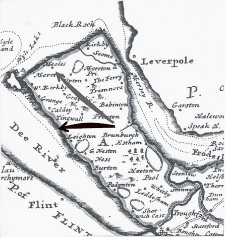
Above: Map of Wirral by Moll, 1724.
In 2007 Steve published a peer reviewed paper in the Journal of the English Place Name Society (vol 39, pages 46-57) describing the distribution of the Old Norse topological names referring to marshy, wetland areas - namely carrs (Old Norse kjarr - brushwood on a marsh) and holms (Old Norse holmr - island of dry land in a marshy/wetland area) - and then its relevance to the Battle of Brunanburh. It develops a suggestion he made in April 2004 that Dingesmere in the Old English poem The Battle of Brunanburh referred to the "mere" (waterway/wetland) of the "Thing" (the Old Norse assembly at Thingwall) - an idea that was later published by Steve, also in JEPNS in October 2004 with Paul Cavill and Judith Jesch. Steve initially suggested the coastal area was the Dee around Heswall but then I extended this to include the area around Meols based on the distribution of very large numbers of carrs and holms around the Rivers Birket and Fender.
Despite being available open access since 2007 on
since its publication this article seems to have been missed by just about everyone including a recent article by Deakin and the author of the Brunanburh Wikipedia page despite appearing in Livingston's edited book "Brunanburh: A Casebook" (Exeter University Press, 2009) and in the 3rd edition of Ingimund's Saga (Chester University Press, 2016).
The main body article we have already referred to in this blog https://profstevehardingvikingwirral.blogspot.com/2022/02/wirral-minor-and-field-names.html
For the benefit of those interested in Brunanburh, we repeat the section of the article that refers specifically to this:
Connection with the battle of Brunanburh
Finally, it is worth commenting on the possible (and perhaps unexpected)
relevance of the carrs and holms to the battle of Brunanburh. This battle
was fought in AD 937 by a force of Dublin Norsemen led by Olaf
Guthfrithsson – known in Old English sources as Anlaf – with Celtic
allies, principally from Scotland, against a combined English army led by
King Æthelstan of the Mercians and West Saxons, coming from the
Midlands and the south. The only contemporary record of the battle is in the form of a poem, recorded in versions of the Anglo-Saxon Chronicle
for the year 937 (A, Corpus Christi College, Cambridge 173; B, British
Library Cotton Tiberius A vi; C, Cotton Tiberius B.i; D, Cotton Tiberius
B. iv and one manuscript now lost). The poem tells of the battle taking
place ymb Brunanburh, i.e. ‘around Brunanburh’ and of Anlaf’s defeated
force escaping on Dingesmere, then across the deep waters of the Irish
Sea back to Dublin (Campbell 1938: 115):
Gewitan him þa norþmen nægledcnearrum,
dreorig daraða laf, on Dingesmere,
ofer deop wæter Difelin secan,
eft Ira land, æwiscmode (53–6)
[Then the Northmen, dreary survivors of the spears, went in
the nail-studded ships on Dingesmere, over deep water, to
seek
Dublin, went back to Ireland ashamed.]
Nobody has been quite sure where the battle took place – the poem only mentions the three place-names Brunanburh, Dingesmere and Difelin – although most scholars accept that Brunanburh is Bromborough on the Wirral (see Cavill 2001: 105–6), Brunanburh being an old form of Bromborough (Figure 5 in the Journal of the English Place Names Society article). The other favoured major sites have included Brinsworth near Rotherham or Burnswark near Dumfries, although the arguments for these sites have been subject to severe criticism (see, e.g., Higham 1997; Cavill 2007). One of the mysteries until recently has been the location of Dingesmere. Earlier proposals had suggested Dingesmere meant ‘the [river] Dee’s mere’ (Dodgson 1957; 1967) or ‘the noisy sea’from the variant spelling Dinnesmere but these have been dismissed on linguistic grounds (PN Ch 4: 240). A more plausible suggestion was made by Cavill, Harding and Jesch (2004) that Dingesmere actually means ‘the Thing’s mere’, i.e. ‘water, or water feature overlooked by, or controlled by, the Thing’. Not far from Bromborough is Thingwall, the centre of the (Wirral) Scandinavian settlement and site of the Thing – its assembly field or parliament. The -mere appears to come from OE mere ‘wetland’ or ON marr ‘marsh’, rather than ‘sea’, and the term was used to warn travellers coming by sea or from the Dee to the Thing, of the presence of this feature. In considering a likely site on Wirral where this ‘Thing’s mere’ might be, Cavill et al. suggested (because of its proximity) a region of wetland/marshland around the coast at Heswall (JEPNS Figure 5), approximately 4km from Thingwall, with the caveat that this coastline would have been different in the 10th century. Such a site would not necessarily have been the point of landing of Olaf’s fleet, but might have been a site at which some sort of craft for part of a force to escape from was located, or to which a skeleton fleet could quickly have been moved from where the fleet was moored (possibly Meols, then, with its natural harbour, Hyle Lake, one of the main sea-ports in the Irish Sea region).
This present analysis of the existence and distribution of the large number
of minor names expressing marshy features reinforces this view, although
the analysis is also consistent with the coastal wetland or marshland of
Dingesmere being near Meols itself (JEPNS Figure 5).
Conclusion
The distribution of topographical minor names tells us as much about the
distribution of natural features as it does about the people who named
them. In the case of the Wirral carrs and holms, the high density in the
former Norse enclave tell us about the distribution of boggy ground
before the modern construction of the sea defences. It also reflects the
persistence of the Scandinavian dialect throughout the centuries, and the
absence of the corresponding English names for the same features is
testament to the dominance of this dialect in the medieval period. This
conclusion is also reflected in a recent sociolinguistic study (Coates 1998)
and further strengthened by evidence from recent genetic studies, which
shows a population admixture for the area of around 50% Celtic and 50%
Norse (Bowden et al. 2007).
For the references - see the full article in
Steve and Sue, 3rd March 2022

Comments
Post a Comment